Feedback sought on plan to develop Levin’s largest residential area
Published on August 11, 2020
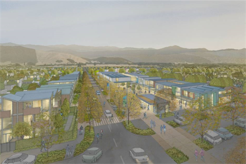
The Taraika Master Plan is a proposal to develop 420 hectares of land, previously known as Gladstone Green, to the southeast of Levin – it will be the most significant residential development in the history of the district.
The proposed development will be home to approximately 2,500 homes, parks, reserves, a local shopping centre, an education facility, stormwater retention areas, and several roads and a shared pathway will connect the development with Levin.
Horowhenua Mayor Bernie Wanden said Horowhenua needs more land zoned as residential if it is to meet the demand of our growing population.
“The Greater Wellington Region has named Horowhenua as a growth area as we will soon be less than an hour’s drive from downtown Wellington,” said Mayor Wanden.
“We estimate that we’ll need to build 400 houses every year for the next decade, and Taraika will go some way toward meeting the demand.”
Council developed the Master Plan in partnership with landowners, Waka Kotahi NZ Transport Agency, the Ministry of Education and Muaūpoko Tribal Authority Inc.
Muaūpoko gifted the name 'Taraika' to continue the thousand year old native custom known as Take Taunaha, essentially a statement that confirms Muaūpoko as Tangata-whenua. Other examples are: Tararua Ranges, Whanganui a Tara, Roto a Tara and the full name of Kapiti Island.
Muaūpoko Tribal Authority Chair, Tim Tukapua said it is auspicious to commemorate Taraika, our ancestor who settled this region over a thousand years ago as te Iwi o Ngai Tara, Muaūpoko are the people of Ngai Tara.
Horowhenua District Council Chief Executive David Clapperton said throughout the process Council has worked to ensure Taraika will be well connected to Levin and be developed alongside the Ōtaki to north of Levin Expressway.
“We want to ensure that Taraika is part of Levin with connections over the expressway for vehicles, pedestrians and cyclists.”
Group Manager Customer and Strategy David McCorkindale said the Master Plan establishes a framework to guide the development of the area such as housing density, open space areas, the layout and nature of infrastructure including roads and shared pathways, and other key features and constraints.
“The planning process allows the effects of large-scale development of land owned by several different people to be better understood and managed, while still allowing flexibility for developers/landowners to design their developments according to their style and preferred design outcomes.”
The engagement process runs from Monday 10 August 2020 through to 5pm on 7 September 2020. Feedback gathered through the engagement process, will be used by Council officers to refine the Draft Master Plan and District Plan Change. Following this, a Proposed District Plan Change will be formally notified allowing for submissions and a hearing to be held.
The Taraika Master Plan document, frequently asked questions and feedback forms can be found at horowhenua.govt.nz/Taraika. An online survey will run as part of the engagement process through Council’s social media channels.
To find out more please email growth@horowhenua.govt.nz
Or come along to one of four drop in sessions at Te Takeretanga o Kura-hau-pō at the following times:
- 4pm-7pm on Wednesday 26 August
- 9am-1pm on Thursday 27 August
- 1pm-5pm on Friday 28 August
- 10am-1pm on Saturday 29 August.